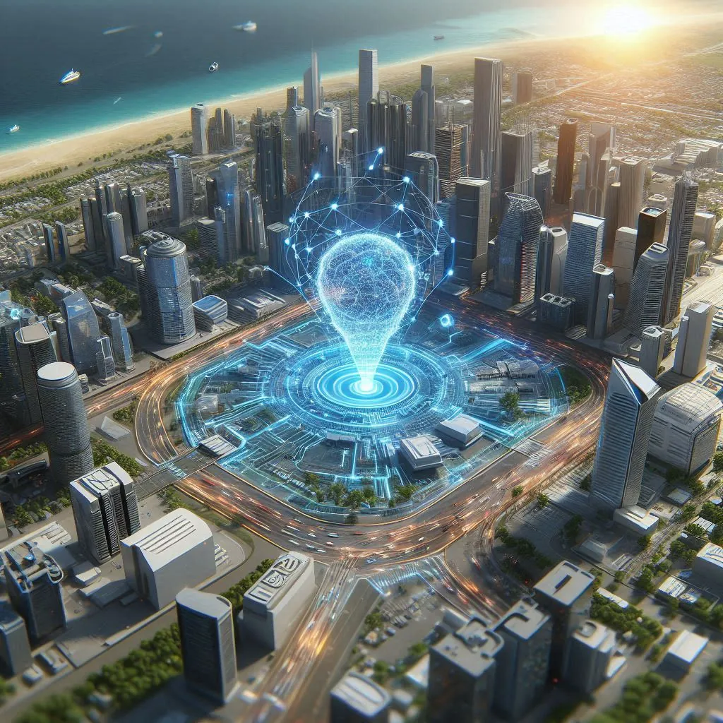
GeoAI Solution Architecture: Integrating Geolocation and Artificial Intelligence

Translated from the original Portuguese article. Ler o original em português

It's been a long time since I last posted anything here on the blog. But recently, while looking at search trends on Google Trends, I noticed a remarkable rise in interest in this topic. That's not surprising, considering how the integration of geospatial data and artificial intelligence is fundamentally transforming the way we interact with this data.
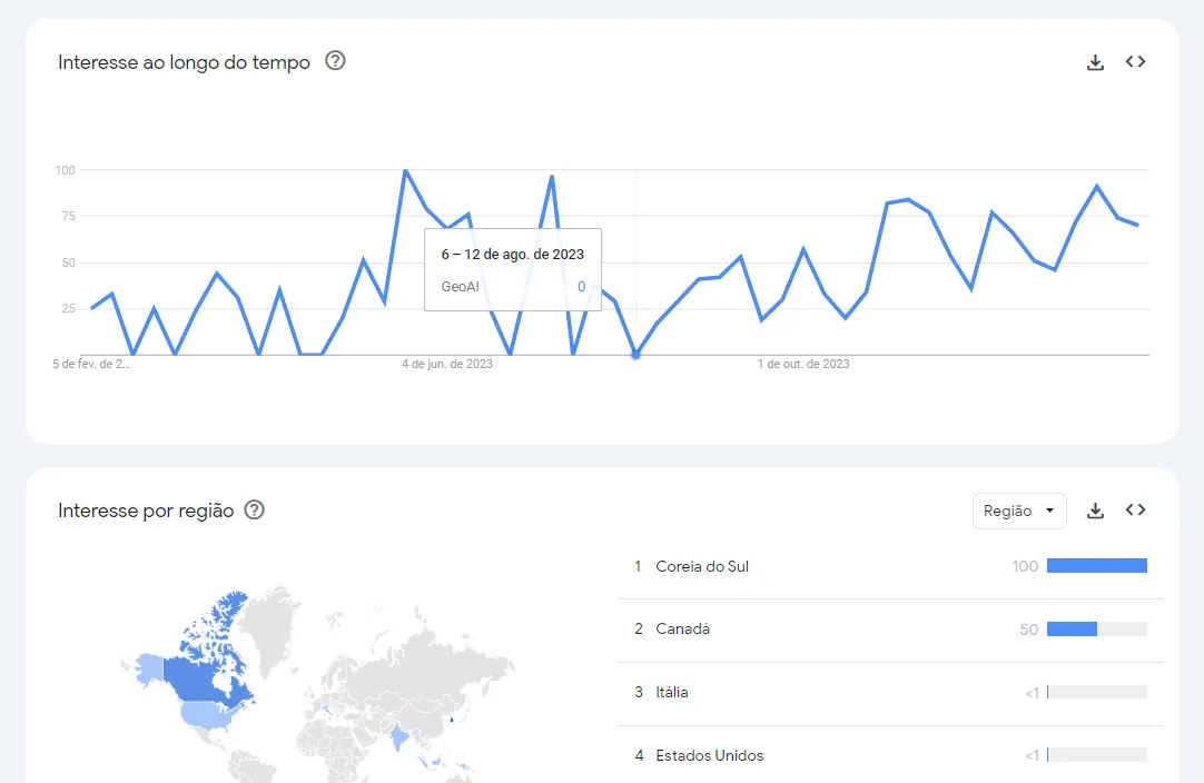
This evolution and the maturity of these techniques, given how efficiently they solve business problems, is one of the main reasons for the growing fascination with the field of GeoAI.
What is GeoAI?
GeoAI is the application of artificial intelligence techniques, such as machine learning, deep learning and natural language processing (for example, Large Language Models, or LLMs), to analyze and interpret geospatial data. Broadly speaking, geospatial data includes information such as GPS locations, satellite images, maps, dashboards and other geographic sources, covering anything that carries location information or makes it possible to locate something, such as addresses.
However, that is not 100% of the power of this field. GeoAI is not just about the application itself, but about solving customer problems in a practical and innovative way using these technologies. For example, in urban planning, GeoAI can help build predictive models for infrastructure planning, while in agriculture it can help optimize the use of natural resources based on soil and climate data.
This is where the added value of GeoAI lies: its ability to fuse complex spatial data with the analytical sophistication of artificial intelligence. This connection unlocks a deep understanding of patterns and trends that takes geographic complexity into account, producing more accurate insights and, overall, more strategically effective actions. And the complexity intrinsic to GeoAI highlights the importance of consultative, strategic thinking when designing solutions.
Successfully implementing GeoAI solutions depends not only on the technology itself, but also on a holistic, well-grounded approach to Solution Architecture. This means adopting industry best practices and adapting them to the specific needs of each case, ensuring solutions that not only solve complex problems but are also sustainable, scalable and aligned with the client's strategic goals.
Key Components of GeoAI Solution Architecture:
Because of all this complexity, it is crucial to pay attention to a few key points that, in my opinion, are extremely important for building effective and reliable GeoAI solutions. The six key points are:

Data Quality and Integrity: The accuracy and reliability of the collected geospatial data are fundamental. It is essential to ensure the data is high quality, up to date and error-free, since it forms the basis for every analysis and insight the system produces. It is worth including several processes, even redundancy and quality procedures, whether automated or not.

Architecture Scalability and Flexibility: Solutions must be designed to scale in order to handle the exponential growth in geospatial data volumes. In addition, the architecture must be flexible enough to adapt to new technologies and data sources that may emerge.

Data Security and Privacy: With growing concerns about data privacy and security, it is CRUCIAL to implement rigorous protocols to protect the data that is collected and processed. This includes complying with data privacy regulations, such as Brazil's LGPD, and applying data security techniques such as encryption and even blockchain.

Advanced Analytics and AI Algorithms: Extracting valuable insights from the data requires advanced AI and machine learning techniques. This involves not only applying existing algorithms, but also developing new methods, model ensembles and multimodal solutions tailored specifically to the complexities of the data and the problems.

Adapting to Change and Continuous Innovation: The GeoAI field is constantly evolving, with new technologies and methodologies emerging practically every week. Solutions must therefore be adaptable and evolvable, incorporating innovations and responding to changes in market demands and conditions, or even in the problems themselves.

Aligning Expectations with Data Limitations: A very important point when designing this kind of solution is realistically aligning expectations with the limitations of geospatial data, especially satellite imagery, which faces challenges such as limited resolution, varying revisit frequency, and obstructions such as cloud cover.
That said, it is essential to emphasize the unique value of this data, which, despite its limitations, offers insights and perspectives unattainable by other means. This balanced communication ensures that users understand both the limitations and the significant potential of geospatial data and its applications.
There are many practical applications for GeoAI solutions; I like to say that the "limits lie in the developer's creativity and in data availability". The opportunities are vast, ranging from advanced urban planning to the most sophisticated monitoring and alerting techniques. Below, I'll show a few diagrams and systems, giving a high-level view of the data flow and business logic using the Minimalist Development Language Specification (MDL) 2.0.
A very interesting example is change detection, which makes it possible to monitor and analyze changes over time in urban and natural environments. Using satellite images, we can identify patterns of urban growth, infrastructure expansion or changes in land cover, such as deforestation or real estate development. An example solution is shown below:
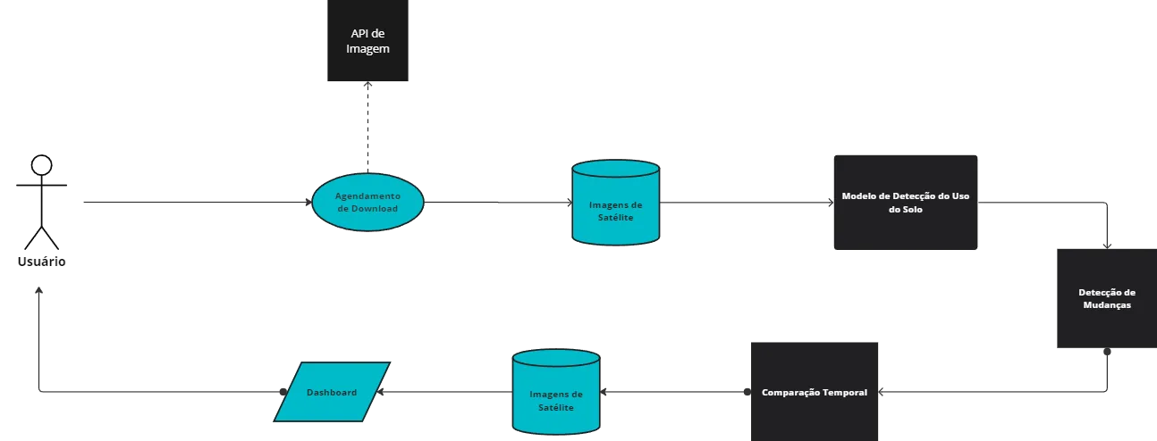
The diagram describes a system in which satellite images are collected periodically through an API, following the configuration and schedule set by the user. After checking for new images and storing them, the images are processed by a land use detection model to identify and classify geographic features. Once the classification results are ready, change detection comes into play, comparing them over time to reveal transformations in the urban or natural environment. Finally, the results of these analyses are displayed on a dashboard, allowing users to track the progress and trends of urban development and changes in natural resources, or even check alerts about unplanned expansion.
Another application is Logistics and Route Management, a field that faces the constant challenge of keeping operations efficient in the face of dynamically changing road conditions. In this context, the system is designed as a solution to optimize the monitoring and reconfiguration of vehicle routes.
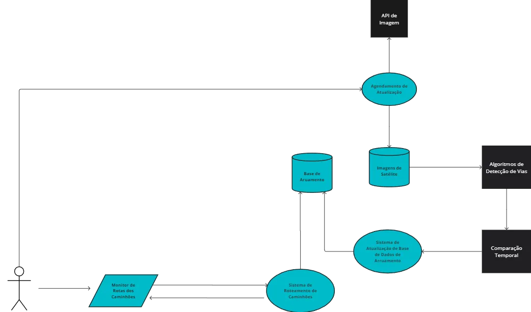
The process starts with the acquisition of satellite images through a configured API. These images are processed by road detection algorithms, which update the database with the new terrain configuration. The updated information is then used to plan and replan vehicle routes, optimizing deliveries or the coverage area of field teams.
Another increasingly necessary application is Environmental Monitoring and Disaster Management. In this case, the system uses several different data sources, reflecting the complexity and interdisciplinary nature of GeoAI solutions. This solution builds a system infrastructure that fuses satellite imagery, climate information and social insights derived from social media data, in order to provide a holistic view of potential environmental crises.
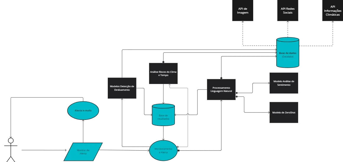
The system is structured like the previous ones: satellite images are acquired on predefined schedules, ensuring regular access to up-to-date imagery of the terrain. In parallel, social media data and climate information are captured in real time, offering a dynamic, current view of social and environmental conditions.
When an event triggers the alerts preconfigured in the social media monitoring or climate analysis models, an emergency procedure is launched to immediately request specific satellite images, strengthening the incident response. This protocol is complemented by an automated communication system that sends email notifications and direct messages to both the public and the relevant authorities, ensuring a fast, coordinated response to potentially risky situations.
In conclusion, the practical applications of GeoAI unfold into a range of possibilities that go beyond the traditional limits of geospatial data analysis. GeoAI solutions are complex, and that is why they are often presented as a black box. However, the complexity lies not only in their technical architecture, but also in the depth with which they address and solve practical problems. Each key point discussed is not an isolated element, but a piece of an intricate puzzle that, once assembled, unlocks extraordinary possibilities for strategic and operational decision-making.
This complexity, far from being an obstacle, is the lever that enables solutions that not only tackle today's challenges but also pave the way for future innovations. In short, the key components underline the need for a holistic and strategic approach to building systems that are robust, adaptable and aligned with the nuances and demands of fast-moving environments and business problems.